Live stream: luca-buoninfante
Recording: reveil cava de' tirreni - luca buoninfante
Cava de' Tirreni, Salerno, Italy
Luca Buoninfante, Raffaele Mariconte, Leandro Pisano
Latitude: +40.707250°
Longitude: +14.710667°
Dawn chorus stream from Cava de' Tirreni, in binaural mode.
http://www.interferenze.org/
http://www.interferenze.org/
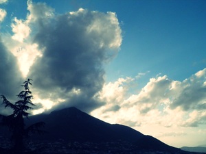
The city of Cava de’ Tirreni is located close to the Tyrrhenian Sea, 3.1 miles inland (north) of the Amalfi Coast. The inhabited area lies approximately 649 feet above s.l., in the Metelliana Valley, which is situated between two mountain ranges: the Monti Picentini on the west (Monte Caruso, Monte Sant'Adiutore, Monte Castello, Monte Stella, Monte San Liberatore, Colle Croce – mostly made up of dolomite rocks), and the Monti Lattari on the east (Monte Finestra, Monte Sant’Angelo, Monte San Martino, Monte Crocella – mostly carbonate rocks). The highest peak is the Monte Finestra (3733 feet above s.l.). The specific conformation of the area – with the highway and railroad cutting across the lowest point of the valley and the Monte Castello lying exactly in the middle of it – gives the Metelliana Valley a distinctive character with its own climatic and acoustic peculiarities. Anthropic sounds and rural sounds coexist, prevailing on one another depending on the moment of the day or the year. This year, reveil will be broadcast from the hamlet of Pregiato, situated on the slopes of the Monte Castello, facing west.